Algorithmic Data Analytics for Geodesy
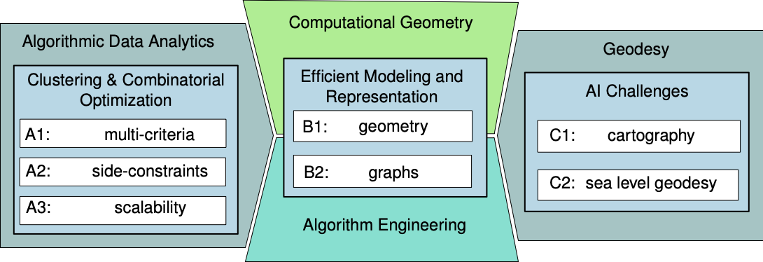
The goal of our Research Unit AlgoForGe (DFG KI-FOR 5361) is to study the algorithmic challenges of
fundamental AI problems in geodesy and develop data analysis methods and tools. The RU has been
selected in July 2022 as one of eight new AI research units by the German Research Foundation (DFG);
the first funding period started in December 2022.
Geodesy measures and represents the Earth's land and sea surface and works with large, heterogeneous
spatio-temporal data, from sea-level measurements to buildings, road networks and administrative regions.
We state the tasks of clustering, aggregating and simplifying such geometric data as explicit
(often multi-objective) optimization problems, solve them with provable guarantees, and validate the
methods on real data. Our two application fields are automated cartography with interactive maps and
sea-level geodesy. Selected results are presented on our publications page.
News
- How much are the world's oceans warming? The University of Bonn has published a press release on our new estimate of ocean heat uptake, which combines satellite gravimetry, satellite altimetry and Argo profiles. It has since been picked up by several press offices. Paper: B. Uebbing, K. Vielberg, R. Rietbroek, B. Aschenneller, A. Köhl, J. Kusche, Earth System Science Data 18, 2026 (doi); dataset on PANGAEA – C2
- Our paper “Weisfeiler and Leman Follow the Arrow of Time: Expressive Power of Message Passing in Temporal Event Graphs” (F. Heeg, J. Sauer, P. Mutzel, I. Scholtes) has been accepted at NeurIPS 2026 – B2.
- Two papers have been accepted at ACM SIGSPATIAL 2026: “geomGMD: Translation- and Rotation-Invariant Geometric Graph Mapping Distance for Building Footprint Similarity” (L. Bülte, A. Naumann, J. Schlurmann, J.-H. Haunert, P. Mutzel) and “Temporally Consistent Aggregation of Building Footprints” (P. Mayer, A. Naumann, F. Roth, A. Bonerath, J. Sauer, P. Mutzel, J.-H. Haunert) – both B2, C1.
- Seven papers by members of the research unit appear at the European Symposium on Algorithms (ESA 2026):
- “Bicriteria Polygon Aggregation with Arbitrary Shapes” (L. Blank, D. Eppstein, J.-H. Haunert, H. J. Haverkort, B. Kolbe, P. Mayer, P. Mutzel, A. Naumann, J. Sauer) – B1, B2, C1
- “Strong ILP Formulations for the p-Regions Problem” (D. Faber, J.-H. Haunert, P. Mutzel) – B2, C1
- “Optimality-Preserving Data Reduction for Maximum k-Cut” (M. Kaibel, P. Mutzel) – B2
- “Time Series Decomposition Using the Fréchet Distance” (A. Driemel, J. Höckendorff, I. Psarros, C. Sohler) – A3, B1
- “New Algorithms and Hardness Results for Connected Clustering” (J. Eube, H. Röglin) – A1
- “Sublinear Algorithms for Estimating Single-Linkage Clustering Costs” (P. Peng, C. Sohler, Y. Xu) – A3
- “Dimension Reduction for Curves: Simplified and Generalized” (M. Ebbens, J. Lu, A. Munteanu) – A3
- Lotte Blank (B1) received the Best Student Paper Award at SoCG 2026 for “Fréchet distance in the imbalanced case”.
- Our joint survey “Geoinformation perspectives on recent developments in algorithm engineering and computational geometry” (J.-H. Haunert, A. Driemel, P. Mutzel) has appeared in PFG – Journal of Photogrammetry, Remote Sensing and Geoinformation Science – B1, B2, C1.
- Completed doctorates: Annika Bonerath (C1, 2024), Jonas Charfreitag (B2, 2025), Peter Rottmann (C1, 2025), Jan Eube (A1, 2026).
Approach and Concept
- represent input data geometrically
- focus on unsupervised learning
- state as discrete optimization problem
Key Tasks
- Dealing with geometric objects (points, lines, polygons, trajectories, triangulations, geometric graphs)
- Solving the tasks: Aggregation, Simplification, Clustering
Our Team
Our interdisciplinary team consists of members of the University of Bonn, the University of Cologne, and
Heinrich Heine University Düsseldorf
from the areas of computer science, cartography, and geodesy.
We have expertise in, e.g., algorithm engineering, approximation algorithms, cartography, clustering,
core sets,
Fréchet distance, GIS, graph optimization,
interactive maps, multi-objective optimization, smoothed analysis, sea level geodesy, streaming,
sublinear algorithms, and
triangulations.